Photo Above: The full length of the Cuillin Ridge as viewed from Glen Talisker which lies to the west. The peak at the far right (south) end is Ghars-bheinn and that on the left is Sgurr nan Gillian. Note the snow patches which still remained in May when this photo was taken.
These notes are intended to assist the walker and climber of considerable mountain experience who wishes to undertake the Cuillin Ridge. They are brief and not designed to be comprehensive in any way.
Ultimately mountaineering is a dangerous sport and claims many casualties each year. One of the guiding principals of British climbing and mountaineering is that it is the individual climber is responsible for his or her own safety. If you cannot accept this then this site and probably climbing in general is unlikely to suit you. May we refer you to this very interesting site instead!
The Cuillin Ridge is the traverse of the main summits of the Black Cuillin Mountains in Skye, one of the Western Isles in the Inner Hebrides off the west coast of Scotland. Although the climbing technicalities are not great, the route is extremely long and exposed and calls for competent soloing at Diff (and occasionally Severe) standard in boots or running shoes on occasionally wet and sometimes dubious rock, combined with good stamina. It is important that you are competent in belaying and moving together "alpine style" ie shortening the rope and hitching it over flakes and nubbins on the move. There are only certain points at which it is easy to quit the Ridge and most of these leave you a considerable distance from a road which carries little traffic. Navigation is particulary complex. Compasses can be affected by the magnetic rock (hold it well away from the rock when taking a bearing, and take your bearing several times in different places). Mist when it descends (which can be often) is very disorientating and can linger for days. Even parties which know the ridge well are hard put to navigate in these conditions. The Cuillin Ridge is not really a rock climb at all - it is much better to think of it as a long and arduous alpine route of reasonable technicality that requires both stamina and experience for a successful attempt.
The Summer Traverse of the Cuillin Ridge
Having said all that, the Summer Traverse of the Ridge is a superb and very satisfying expedition. It is generally undertaken from south to north in summer so that the major difficulties are climbed and your day ends at a pub! There are two main approaches, either in a day which should take a competent party soloing nearly all difficulties around 12 to 14 hours from the Glen Brittle Campsite to the Sligachan Hotel, with around 7 or 8 hours being required for the Ridge itself (ie from the summit of Gars-bheinn in the south to the summit of Sgurr nan Gillean in the north).
Photo: Looking north from the southern-most peak of Gars-bheinn - a daunting sight! The high 'double peak' is Sgurr Alasdair (on the left) and Sgurr Thearlaich (on the right). Sgurr nan Gillean, the final summit, is the far off cone-shaped peak before the obvious gap of Glen Sligachan.
Approximate times that a party who needs to rope up for the harder sections might expect from Gars-bheinn are:
| Sgurr nan Eag |
1 hour |
| TD Gap |
2½ hours |
| Sgur Dubh Mor |
To tick this outlying Munro, add about 45 mins |
| Innaccessible Pinnacle |
5½ hours |
| Druim nam Ramh |
8½ hours |
| Am Bhasteir |
11 hours |
| Sgurr nan Gillean |
12 hours |
The current summer record stands at an amazing 2hrs 59mins 22secs and is held by Finlay Wild.
An alternative approach is to take two or three days and carry bivi kit and food (or stash them in advance). Whichever way you choose it is essential to carry plenty of water as there is no supply on the Ridge. 2 litres per person per day plus extra for cooking if bivouaccing should suffice. However, by descending with care from the ridge, it is possible to reach water in the corries - so take a 10 litre waterbag, (plus 2m of clear plastic siphon tubing and a mug) to fill for your bivis.
| Reliable Water Sources off the Cuillin Ridge |
Grid Ref |
| Just off the south-west side of bealach between Gars-bheinn and Sgurr nan Eag some pools will be seen. |
NG 461 191 |
| Spring below west side of TD Gap, reached by scrambling down the rather loose gully. |
NG 4512 2065 |
| West side of Bealach Coire na Banadich. This is the first major pass north of the Inn Pinn and a useful one to know about. |
NG 44059 21608 |
| West Ridge of Sgurr na Banadich. There are good bivi sites not far down this ridge from the summit, so carrying on down the ridge to find water would be logical. |
NG 43523 22693 |
| North side of Bealach na Lice. Marked as a spring on the Harvey Cuillin map. |
NG 463 253 |
| We would be grateful to learn of more water sources with accurate grid references. |
Of these two approaches the former is definitely the best, provided you are fit enough, as you can carry a minimal sack containing little more than a rope, water and sandwiches.
The best time of year for the traverse is generally May and June when stable periods of high pressure can last for weeks and the infamous midges have not yet emerged from their burrows! Long days are an asset too. If going early, check that all the snow has gone. However, if planning the multiday bivi route, lingering snow patches are an advantage as you can melt snow for water (but may need a second gas cylinder).
Photo: Nearing the TD Gap, with the Isle of Rhum in the background.
In summer, the major technical difficulties when approaching from the south are:
| Thearlich-Dubh Gap |
The TD Gap involves a 10m abseil (or downclimbing a steep V Diff) to gain the bottom of the cleft, followed by 20m of Severe greasy chimney crack (Camalot 2 or equivalent is useful). If there is a traffic jam at the Gap (not unusual) then the loose gully leading down west from the Gap may be taken. Contour around to the next ridge which leads back over Alasdair to the main ridge with one tricky step. But of course you will only have to do the whole thing again in the future if you do! |
| King's Chimney on Sgurr Mhic Coinnich |
A superb 25m V Diff. |
| An Stac |
The direct ascent of this to reach the "In Pinn" is possible at about Diff standard, but it is fairly loose and is often avoided by skirting it to the left and walking and scrambling up the screes on its west side (equally loose). |
| Inaccessible Pinnacle |
The "In Pinn" is a steep Moderate climbed via its East Ridge in two pitches (65m). For the 'compleat' Munro tick, one should surmount the Bolster Stone (the huge bolder that forms its highest point). Descent is usually by abseil from a fixed chain down the short West Ridge (20m, Severe). |
| North Top of Bidein Druim nam Ramh |
Parts of the descent from this complex top are often bypassed by short abseils. |
| Naismith's Route |
(85m, Severe) is the accepted way of reaching the Bhasteir Tooth, though easier options exist. |
There are many other places where it would not be unusual to feel the need of a rope.
38m of 7.5mm or 8mm will suffice, but only if you are happy leading Very Difficults and Severes on a single half rope. Official advice would be that whatever rope you carry should be tested to single rope standard and this is certainly what a guide would use, but this adds weight: it remains a matter of individual choice based on assessing the risk. Aside from the rope, 4 or 5 wires, a couple of cams (a Camalot 2 or equivalent is useful for the TD Gap), 6 x 120cm slings and 4 x 60cm slings set up as 'alpine' quickdraws, along with some 'ab tat' is quite enough gear.
Photo: Abseiling into the TD Gap. This wall forms the crux of the winter traverse which is usually tackled north to south and is graded IV (6). Fortunately it is well protected with small wires.
Photo: Climbing the Original Route out of the TD Gap. Once given Difficult, this awkward pitch is now graded Severe and is often bypassed by a long and tedious detour.
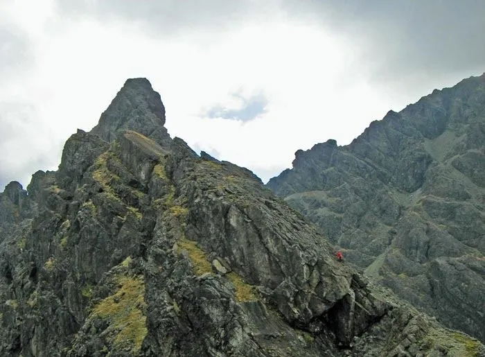
Photo: Scrambling up below the Inaccessible Pinnacle, with a party abseiling off.
Photo: Biviing on the Ridge - midge nets essential!
Photo: A Diff section on Sgurr a' Ghreadaidh. Many parties would rope up for this pitch.
Photo: Am Bhastier and the Bhasteir Tooth. Naismith's Route goes up cracks hidden round to the right.
The Winter Traverse of the Cuillin Ridge
In winter the major difficulty is in finding good conditions. Close proximity to the sea means that although good conditions are present most years, they seldom last long, and though they do form quickly, they generally melt very shortly thereafter. Heavy snowfall followed by a stable area of high pressure bodes well. In which case act at once, take instant leave (or in extremis, quit your job), motor northwards overnight like a fiend (remembering the speed cameras) and take a bivi bag, 4 season sleeping bag, stove and food for two to three days, as well as a reasonable amount of Winter Climbing Equipment (mainly slings - think lightweight!). It is probably best to take a pair of light 50m ropes unless you know the Ridge extremely well, in which case one might suffice. However if you get the ab wrong off Am Bhastier you will definitely need 100m of rope and King's Chimney could cause problems too.
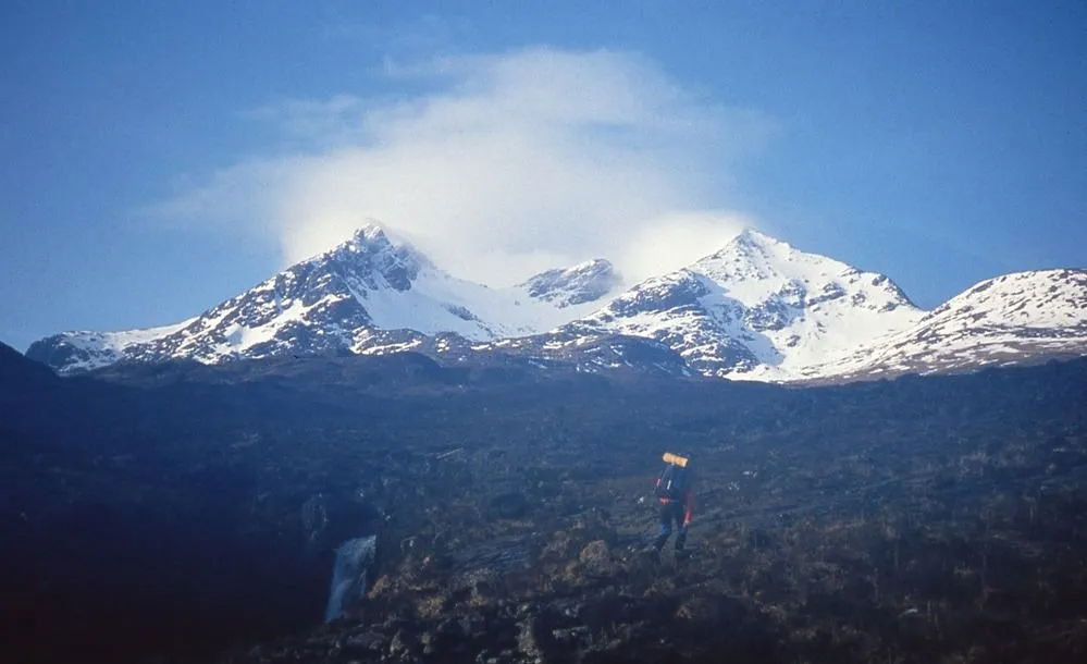
Photo Above: Setting off from the Sligachan for the Bhastier Coirre at the start of a two day traverse of the Cuillin Ridge in Winter. Pinnacle Ridge takes the left hand skyline of Sgurr nan Gillean which is the left-hand peak and makes a great start to a winter traverse.
The Winter Traverse is generally made from north to south as the major difficulties can be bypassed by abseil, though this still leaves a desperate short pitch out of the TD Gap (Grade IV (6) according to the SMC guide). Starting from the north means that Pinnacle Ridge (IV) can be used to reach Sgurr nan Gillean if the conditions are good. There are many good bivi sites along the ridge and water is not a problem in winter. A major difficulty though can be getting a lift back up Glen Brittle to the Sligachan!
The current record for the winter traverse is 4 hours and 57 minutes by Uisdean Hawthorn - however most parties should plan on at least one bivi!
Looking south from Am Bhastier – a long way to go!
Packing up after after a bivi near Bidean Druim nan Ramh (Photo – Mike Osborne).
Photo : The Cuillin Ridge in winter, looking north from Sgurr Mhic Choinnich towards An Stac and the Innaccessible Pinnacle.
Photo: Heading towards Sgurr Mhiccoinnich after descending An Stac.
Photo: The end in sight with just Gars-bheinn to go.
Guidebooks & Maps
The best guidebooks and maps to the Cuillin Ridge are :
| Climbing (includes the Ridge) |
SMC Skye – The Cuillin- Not worth carrying on the Ridge as it's too heavy but photocopying the relevant pages is sensible. Strangely, for a climbing guide, it often makes the difficulties sound much harder than they actually are. |
| Scrambling (includes the Ridge) |
SMC Skye Scrambles – While the above guide will appeal more to climbers, this one is ideal for walkers and scramblers who do not want to go to the expense of buying the full climbing guide. |
| Scrambling (the Ridge) |
Cicerone's Skye's Cuillin Ridge Traverse by Adrian Trendall is an excellent two-part guide (only one part needs to be carried) that includes Harvey mapping so that a separate map is not needed. |
| Scrambling (the Ridge) |
Cuillin Ridge Topo-Guide by Tom Prentice is a very slim volume with photo topos of almost all the major problem areas and is well worth having. |
| Scrambling (the Ridge) |
The Cuillin & Other Skye Mountains by Tom Prentice is an incredibly detailed volume. Far too big to carry with you, it could be a useful reference volume to consult prior to a traverse. |
| Scrambling (the Ridge) |
Rockfax have a downloadable "Mini-Guide" to the Skye Ridge (as they term it). |
| Scrambling (the Ridge) |
Mike Lates has two useful and free PDFs on doing the Ridge in both summer and winter: The Cuillin Ridge - Tips for Success and The Winter Traverse. |
| Map |
The best map is currently Harvey's Skye - The Cuillin, though if you can find a second hand copy of the SMT map The Black Cuillin, that is worth buying too. Both these maps have a simple diagrammatic representation of the Ridge which is ideal for general use, and both show the safe routes down off the ridge should you get caught in bad weather or become too exhausted to continue. The major Ordnance Survey maps, including the Explorer Map of the Cuillins are poor by comparison. |
There are good accounts of the Ridge traverse in summer in:
| The Cuillin |
by Gordon Stainforth |
| Classic Rock |
edited by Ken Wilson |
There are good accounts of the Ridge traverse in winter in:
| Cold Climbs |
edited by Ken Wilson, John Barry & Dave Alcock |
| One Man's Mountains |
Tom Patey's hilarious account of the first winter traverse |
Accomodation for attempting the Cuillin Ridge traverse:
Other Information:
A good view of the weather at the northern end of the Ridge.
| Skye Guides |
A group of locally based instructors, run by Mike Lates, the current SMC guidebook writer. |
| Skye Adventure |
Another locally based group of instructors/guides. While the Ridge is always on the agenda, canoeing and surfing provide good poor weather options. |
| Sligachan Web Cams |
There appear to be two currently, though it's hard to tell if they are working or not: Webcam Sligachan and Sligachan Webcam. |
The Clach Glas Traverse - a mini alternative to the Cuillin Ridge
If you are uncertain as to whether you are quite up to the Cuillin Ridge, you can of course just pick out sections of it at a time and many parties do this as part of their training for the full traverse. However, if you don't wish to spoil the "on sight" (as they say in some branches of our weird and wonderful sport) a good alternative exists in the shape of the Clach Glas Ridge which lies to the east of Loch Coriusk. It is best started via an easy scramble up the East Ridge of Sgurr Nan Each from where the way over Clach Glas to the summit of Bla Bheinn is hard to miss in good weather. Climbing of up to Severe will be encountered if difficulties are taken direct but there are no abseils so it is possible to just take a rope and a few slings for the more difficult sections and dispense with harnesses. Despite being much shorter than the main ridge, this mini version should not be underestimated, especially if the clag is down and the rock wet.
If you can cope with the Clach Glas Ridge you shouldn't have any problems on the Cuillin Ridge beyond keeping going for about ten times as long!
Left: The Clach Glas traverse with Sgurr Nan Each on the right, Clach Glas in the centre, and the twin summits of Bla Bheinn on the left.
Below: Speck in the landscape. Sally Baxendale heads up towards the summit of Clach Glas.
"You know Alf, going to the right place at the right time, with the right people is all that really matters. What one does is purely incidental."
Colin Kirkus to Alf Bridge on the summit of Sgurr Alasdair